📸 How it went


What is included
Route program
Group meeting and transfer
Participants meet at 3:30 AM, check their gear, and board the transport. At 3:50 AM, we depart through Big Almaty Gorge for the second barrier near Edelweiss.
Al-Farabi - Dulati bus stopAscent along the pipeline to Big Almaty Lake
The hiking section begins with an ascent via the staircase and the trail alongside the water pipeline. As the route starts in the dark, every participant must carry a headlamp. A short rest and snack break is planned near Big Almaty Lake.
Second barrier - pipeline - Big Almaty LakeAscent to Big Almaty Peak
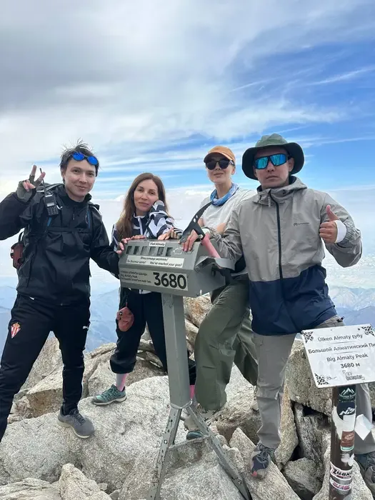
From the lake, we follow the mountain road to the Cosmostation at Zhosaly-Kezen Pass. After a short break, the group continues across scree and rocky slopes to the 3,680 m summit of Big Almaty Peak. Time is planned at the summit for rest, a snack, and photos.
Big Almaty Lake - Cosmostation - Big Almaty PeakDescent to Big Almaty Lake
Descending along the same route used for the ascent. On rocky sections, the group maintains a safe distance to avoid dislodging stones onto participants below. A short technical stop is planned near Big Almaty Lake.
Big Almaty Peak - Cosmostation - Big Almaty LakeReturn and completion of the route
Descending from the lake along the trail beside the pipeline towards Edelweiss. Take extra care on the staircase and steep sections. The hiking section ends at the second barrier at 4:00 PM. We then board the transport and return to the meeting point.
Big Almaty Lake - pipeline - second barrierDescription
Big Almaty Peak is considered one of the most recognisable summits of the Trans-Ili Alatau. Its symmetrical pyramid-shaped silhouette is clearly visible from Almaty, especially in clear weather. Because of its distinctive shape, the summit is also known as the Big Almaty Pyramid.
The route via Big Almaty Lake combines several important locations in Big Almaty Gorge within a single hike: the water pipeline, Big Almaty Lake, the Tien Shan Astronomical Observatory, the Cosmostation and Big Almaty Peak itself. However, this is not a casual walk to the lake. It is a long ascent with substantial elevation gain and a difficult final section.
Key route details
Start and finish: second environmental checkpoint and barrier near Edelweiss
Route: Edelweiss - pipeline - Big Almaty Lake - Cosmostation - Big Almaty Peak
Distance: approximately 30-32 km round trip
Starting elevation: approximately 1,900 m
Elevation of Big Almaty Lake: approximately 2,510-2,511 m
Elevation of the Cosmostation: approximately 3,337-3,340 m
Summit elevation: 3,680-3,681 m
Total elevation gain: approximately 2,100-2,200 m
Duration: 12-15 hours
Route type: out and back along the same trail
Difficulty: high
The actual distance depends on the selected trails and the number of shortcuts taken. Following the pipeline route gives a total distance of approximately 30-32 km. Staying entirely on the winding vehicle roads may increase the distance to more than 35 km.
Starting near the second environmental checkpoint
The hiking section begins at the second environmental checkpoint and barrier near the Edelweiss tourist base. One of the trails beside the pipeline carrying water from the Big Almaty Lake area starts here.
The initial ascent follows a steep metal staircase and a trail beside the pipeline. This section gains elevation quickly and may be harder than it appears on a map. After the staircase, the route crosses the vehicle road several times.
Metal steps, rocks and soil become slippery in wet weather. It is safer to use the trail beside the pipeline rather than walking on the pipeline itself.
Ascent to Big Almaty Lake
The shortened route from the Edelweiss area to Big Almaty Lake is approximately 5-6 km. The ascent usually takes two to three hours, depending on the group’s pace and the length of stops.
Big Almaty Lake sits at an elevation of approximately 2,511 metres. It is a high-altitude reservoir surrounded by peaks of the Trans-Ili Alatau. Its colour varies from grey-blue to deep turquoise depending on the light, cloud cover, season and water level.
Big Almaty Lake forms part of Almaty’s water supply system. Swimming, entering the water and accessing restricted sections of the shoreline are prohibited. Use the permitted viewpoints for breaks and photos.
From Big Almaty Lake to the Cosmostation
The longest continuous ascent begins after the lake. The route turns towards Zhosaly-Kezen Pass and climbs along a mountain road. The forest gradually ends along this section, and the landscape becomes more open and rugged.
The Tien Shan Astronomical Observatory can be seen along the way. It should not be confused with the Cosmostation. The observatory is used for astronomical observations, while the high-altitude research station at the pass studies cosmic rays.
The Cosmostation is located at an elevation of approximately 3,340 metres. Even in summer, it is noticeably colder here than at Big Almaty Lake. Winds often strengthen, fog may develop, and clouds can completely hide the summit within minutes.
Ascent from the Cosmostation to Big Almaty Peak
The summit is approximately 2-3 km one way from the Cosmostation. The distance is short, but this is where the most difficult section of the hike begins.
The trail first traverses the slope and climbs towards a saddle at the foot of the peak. It then crosses loose scree, large rocks and rocky terrain. Chains and route markers are present in some sections, but they should not be relied upon as the only means of navigation or safety.
There are many unstable rocks underfoot. Group members must keep their distance and avoid walking directly below one another. A dislodged rock could injure someone lower on the slope.
Big Almaty Peak has a southern summit and the main northern summit. Reaching the northern point is more difficult and requires dry weather, confident movement over rocks and comfort with exposed terrain. In snow, ice, strong winds or poor visibility, it is safer to stop at a secure point and begin the descent.
Views from the summit
In clear weather, Big Almaty Peak offers views of Almaty, Big Almaty Lake, Zhosaly-Kezen Pass, the Cosmostation, Prokhodnoye Gorge and neighbouring peaks of the Trans-Ili Alatau.
The city is only approximately 15 km away in a straight line, but the elevation difference between Almaty and the summit exceeds 2,800 metres. This makes Big Almaty Peak clearly visible from the city, while the summit offers a broad panorama of the foothills and plains.
Returning to Edelweiss
The descent follows the ascent route:
Big Almaty Peak - Cosmostation - Big Almaty Lake - pipeline - second environmental checkpoint.
Do not descend directly towards the lake along the eastern slope. It contains steep scree, exposed rock and dangerous sections without a reliable trail.
Fatigue and strain on the knees are the main challenges on the return journey. More than 13 km remain after leaving the summit. Allow enough daylight and do not remain high on the route if the weather deteriorates.
How long does the hike take?
Estimated time breakdown:
Second environmental checkpoint to Big Almaty Lake: 2-3 hours
Big Almaty Lake to the Cosmostation: 3-4 hours
Cosmostation to Big Almaty Peak: 2-3 hours
Summit to the Cosmostation: 1.5-2 hours
Return to Edelweiss: 3-4 hours
The full route takes approximately 12-15 hours. A slower group or conditions involving snow, fog or strong winds may require more time. A very early start is necessary to complete the route in one day. Less experienced hikers should consider splitting the route over two days, with an authorised overnight location arranged in advance.
Who is this route suitable for?
The hike is intended for people who regularly complete mountain routes of at least 20 km and have experience moving across scree and easy rocky terrain. Beginners should not choose this ascent as their first mountain experience without appropriate guidance.
The final ascent is not the only challenge. The 30-32 km distance, more than 2,000 metres of elevation gain and rapid ascent above 3,500 metres place significant demands on the body.
What to bring
Recommended equipment includes:
Hiking boots with non-slip soles
Trekking poles
A windproof and waterproof jacket
A warm layer, hat and gloves
A headlamp with spare batteries
Sunglasses and sun protection
At least 2-3 litres of water
High-energy snacks and a substantial meal
A first-aid kit and emergency blanket
A power bank and downloaded offline map
An identity card or passport
A lightweight helmet for the upper section where rockfall is possible
Natural water sources should not be treated as guaranteed. Their condition and availability change with the seasons, so the main water supply must be carried from the start.
Weather and seasonality
The most suitable period for the ascent is usually during dry months when the upper route is free from snow and ice. Even in summer, temperatures at the Cosmostation and summit may be close to freezing.
Cloud cover often increases in the afternoon, winds strengthen and visibility deteriorates. Continuing towards the summit during a thunderstorm, dense fog, fresh snow or icy conditions is dangerous.
Documents and restrictions
Above Big Almaty Lake, the route passes near the border zone and active research facilities. Participants should carry a valid identity card or passport. Access rules may change, so check the current requirements and whether a permit is needed before the hike.
Private vehicle access to Big Almaty Lake is restricted. Transfers usually take participants only as far as the permitted point near the barrier and Edelweiss, where the hiking section begins.
Why choose this route?
The route to Big Almaty Peak via Big Almaty Lake combines a forested gorge, an engineering trail beside the pipeline, a high-altitude lake, research stations and a genuine summit ascent. The landscape changes from coniferous forest to rocky alpine tundra within a single route.
This is a difficult and lengthy hike requiring preparation, discipline and careful time management. Its reward is the panoramic view over Big Almaty Lake, Almaty and the central section of the Trans-Ili Alatau.
За что можно любить горы - здесь быстро понимаешь, кто ты)
БАП - не просто прогулка на выходных. Здесь ты успеваешь устать, замолчать, снова заговорить, иногда пожалеть о своём решении, посмотреть вокруг и подумать: «какая же это красота»! 😍
И снова Айдын 😎 Спокойный, внимательный, с юмором и каким-то удивительным умением сделать так, чтобы даже сложный маршрут воспринимался как приключение, а не как испытание)
За несколько походов совершенно чужие люди превратились в тех, с кем можно смеяться на подъёме, делиться перекусом, обсуждать жизнь на привале и радоваться вершине как будто все мы знакомы много лет.
В такие моменты понимаешь, что уже ходишь не просто в походы, а ждешь встречи с людьми ❤️
Всё было супер. Незабываемый поход.
Акжол


