
📸 How it went


What is included
Route program
Group meeting and transfer
Participants meet at 07:30 for a gear check and a short safety briefing. At 07:50, taking the transfer to the second eco-checkpoint near Edelweiss. The hike is expected to begin at around 08:10.
GES-2 bus stopAscent to Moon Glade
Hike uphill along the water pipeline, then continue towards the Alpine Rose area. From there, the group follows a dirt road to Moon Glade. Short stops are planned along the way to rest and regain pace.
second eco-checkpoint - water pipeline - Alpine Rose - Moon GladeShukur Waterfall and Skalisty Peak
Hiking through the forest and along the stream to Shukur Waterfall. After the waterfall, a steep ascent begins across grassy slopes and scree. We reach Skalisty Peak at approximately 3,332 metres. A short rest, snack break, and time for photos are planned at the summit.
Moon Glade - Shukur Waterfall - Skalisty PeakDescent to Moon Glade
Descending along the same route used for the ascent. On scree slopes, participants keep a safe distance and avoid walking directly below one another. Short technical stops are planned near the waterfall and at Moon Glade.
Skalisty Peak - Shukur Waterfall - Moon GladeReturn and completion of the route
DescendING through the Alpine Rose area and along the water pipeline. The hiking section is expected to finish near the second eco-checkpoint at around 16:00. We then take the transfer back to the GES-2 bus stop, arriving at approximately 16:30.
Moon Glade - Alpine Rose - second eco-checkpoint - GES-2Description
Skalisty Peak is located in Big Almaty Gorge, south of Moon Glade and east of Big Almaty Lake. The peak takes its name from its distinct rocky terrain, steep slopes and exposed rock formations.
Despite its relatively short distance, the hike requires good physical fitness. The main challenges are the substantial elevation gain, the steep ascent beyond the waterfall and movement across loose slopes. The upper route is intended for hikers with previous experience of long mountain hikes.
Key route details
Start and finish: second checkpoint and barrier near Edelweiss
Route: Edelweiss - pipeline - Alpine Rose - Moon Glade - Shukur Waterfall - Skalisty Peak
Distance: approximately 15 km round trip
One-way distance: approximately 7-8 km
Summit elevation: approximately 3,332 m
Elevation of Moon Glade: approximately 2,380-2,420 m
Elevation of Shukur Waterfall: approximately 2,615 m
Elevation gain: approximately 1,450-1,500 m
Duration: 8-10 hours, including breaks
Route type: out and back
Difficulty: high
Return: along the ascent route or via a more difficult alternative trail
A circular option descends from the summit towards Big Almaty Lake before returning to the pipeline. It is approximately 16.8-17 km long. The descent crosses steep grassy and scree slopes, making it more difficult than returning directly via the waterfall and Moon Glade.
Starting at the second checkpoint
The hiking section begins at the second checkpoint and barrier near Edelweiss. The starting elevation is approximately 1,800-1,900 metres.
The first section follows a staircase and trail beside the water pipeline. The steep ascent gains elevation quickly and takes the group above the forested part of the gorge. Metal steps and rocks become slippery in wet weather.
At the relevant junction, leave the main direction towards Big Almaty Lake and descend to the road near the Alpine Rose hotel. The entrance to Shukur Gorge and the road to Moon Glade begin here.
Ascent to Moon Glade
From Alpine Rose, the route follows an unpaved road between forested slopes. The gorge gradually widens and reaches a large open area known as Moon Glade.
The name is associated with the scattered pale boulders, open terrain and clear view of the night sky. The location has no direct connection with the Moon or astronomical research.
In spring and early summer, the glade is covered with grass and mountain flowers. Many butterflies and other insects can be seen here. In autumn, the open landscape turns yellow-brown, while the surrounding slopes may receive their first dusting of snow.
Moon Glade is suitable for a longer rest before the main ascent. Trails from here lead towards Big Almaty Lake, Kumbelsu Gorge, Shukur Waterfall and neighbouring mountain routes.
From Moon Glade to Shukur Waterfall
After the glade, the trail crosses a short forest section and continues uphill beside a stream. The waterfall is approximately 1.5-2 km away.
The stream must be crossed several times. Water levels rise in spring and after rainfall, while compact avalanche debris may remain on the approaches. Snow sometimes lasts until early summer in cold, shaded areas.
The waterfall is located in a narrow part of the gorge at an elevation of approximately 2,615 metres. It is around 10 metres high. Its flow depends on the season and is usually strongest during active snowmelt and after prolonged precipitation.
Maps use several versions of the name, including Shukur, Chukur and Shukyr. Shukur Waterfall is the version most commonly used in hiking descriptions.
Ascent from the waterfall to Skalisty Peak
The main ascent begins slightly below the waterfall. The trail leaves the stream and climbs quickly onto the slope. The turn is easy to miss because the upper route has no clear markings.
After leaving the gorge, the route traverses the slope, crosses seasonal drainage channels and gradually reaches open high-altitude terrain. The forest remains below, while grass, small rocks and scree appear underfoot.
The trail becomes less visible with elevation. At approximately 3,000 metres, there is a large boulder known to hikers as Bukhanka, or “the Loaf”, because of its shape. It provides some protection from the wind and a suitable place to rest before the final ascent.
The steepest section lies between the boulder and the summit. Move slowly, avoid walking directly below one another and take care not to dislodge rocks onto hikers beneath you. Trekking poles are useful on loose ground, but hands should remain free on some rocky sections.
Summit of Skalisty Peak
Skalisty Peak has an elevation of approximately 3,332 metres. Different GPS devices may show readings between 3,327 and 3,347 metres because of GPS inaccuracies and differences in map data.
The summit offers views of Big Almaty Lake, Kanysh Satpayev Peak, also known as Sovetov Peak, Big Almaty Peak, Molodezhny Peak, the Cosmostation and Zhosaly-Kezen Pass.
Another rocky elevation is located near Skalisty. Some unofficial maps mark it as a separate summit, but its name and status vary. Attempt the traverse only with sufficient experience, dry terrain and good visibility.
The summit is usually windy. A longer rest is better taken slightly below the ridge in a sheltered location.
Returning to Edelweiss
The most straightforward return follows the ascent route:
Skalisty Peak - Shukur Waterfall - Moon Glade - Alpine Rose - pipeline - second checkpoint.
The descent requires more attention than the ascent. Grass, small rocks and sand may slide underfoot. Tired participants are more likely to lose their balance during the second half of the route.
Descending towards Big Almaty Lake creates a circular route, but it should not be treated as an easy alternative. The upper section crosses a steep slope with a poorly defined trail. This option becomes particularly dangerous after rain, snowfall or freezing conditions.
How long does the hike take?
Estimated time breakdown:
Second checkpoint to Alpine Rose: 1-1.5 hours
Alpine Rose to Moon Glade: 40-60 minutes
Moon Glade to Shukur Waterfall: approximately 1 hour
Waterfall to summit: 2-3 hours
Rest at the summit: 20-30 minutes
Return to Edelweiss: 3-4 hours
The total duration is approximately 8-10 hours. Fast, well-prepared groups may complete the route sooner, but moving quickly across scree increases the risk of falling and dislodging rocks.
Difficulty and main hazards
Skalisty Peak is not a simple beginner route. An active hiker with moderate fitness may reach Moon Glade and the waterfall, but continuing to the summit is considerably more difficult.
The main hazards include:
Substantial elevation gain
Steep grassy slopes
Unstable rocks and scree
A poorly defined trail above the waterfall
Sudden weather changes
Strong winds near the summit
Snowfields and avalanche debris in spring
A slippery descent after rain
Limited water on the upper route
Stop the ascent in fog, thunderstorms, wet snow or strong winds. Turning back at a safe point is more important than reaching the summit.
Best time to hike
The most predictable conditions are usually found between mid-summer and early autumn when the upper slopes are free from snow. However, current route conditions must be checked immediately before the hike.
Spring may bring avalanche debris, snow bridges and streams hidden beneath the snow. In autumn, rocks and grass may become covered with thin ice. A winter attempt requires specific experience, suitable equipment and an avalanche conditions assessment.
What to bring
Recommended equipment includes:
Hiking boots with ankle support
Trekking poles
A windproof and waterproof jacket
A warm layer
A hat and gloves
Sunglasses and sunscreen
A headlamp
At least 2 litres of water
Lunch and several snacks
A personal first-aid kit
A power bank
An offline map or GPS track
A lightweight helmet for protection from falling rocks
Stream water should not be assumed safe to drink. It must be filtered or treated. Carry the main water supply from the starting point.
Who is this hike suitable for?
The route is suitable for hikers who can confidently cover 15-20 km, have experience with more than 1,000 metres of elevation gain and know how to move across scree slopes. Skalisty Peak should not be chosen as a first independent mountain hike.
Those who are not yet ready for the summit can choose the shorter route to Moon Glade or Shukur Waterfall. It covers the main part of the gorge without entering the steep high-altitude slopes.
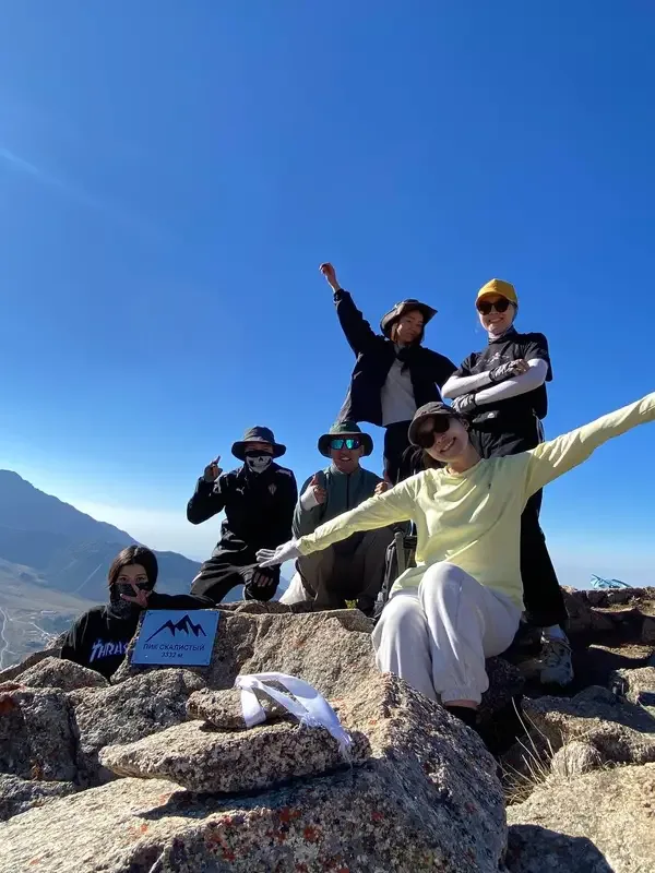
несмотря на свою сложность, поход прошел классно. виды с пика Скалистый очень красивые.
АкжолПушка, проход через лунную поляну, водопад Шукур, а вид с горы потрясающий на пик Сатпаева и БАО 😍
Aidana


