📸 How it went

Route program
Group meeting
Meet point - at the bus stop, get to know the participants, checking our gear, and review the route and safety rules.
Near the bus stopBegin our hike
Begin the hiking section and head towards the ascent to Karakungey Peak.
Lower station of the Medeu - Shymbulak cable carSlonikha and Karakungey
Climb to the Slonikha viewpoint and take a short break for rest and photos. Then we continue towards Karakungey. The ridge offers views of Medeu, Almaty, and the surrounding gorges.
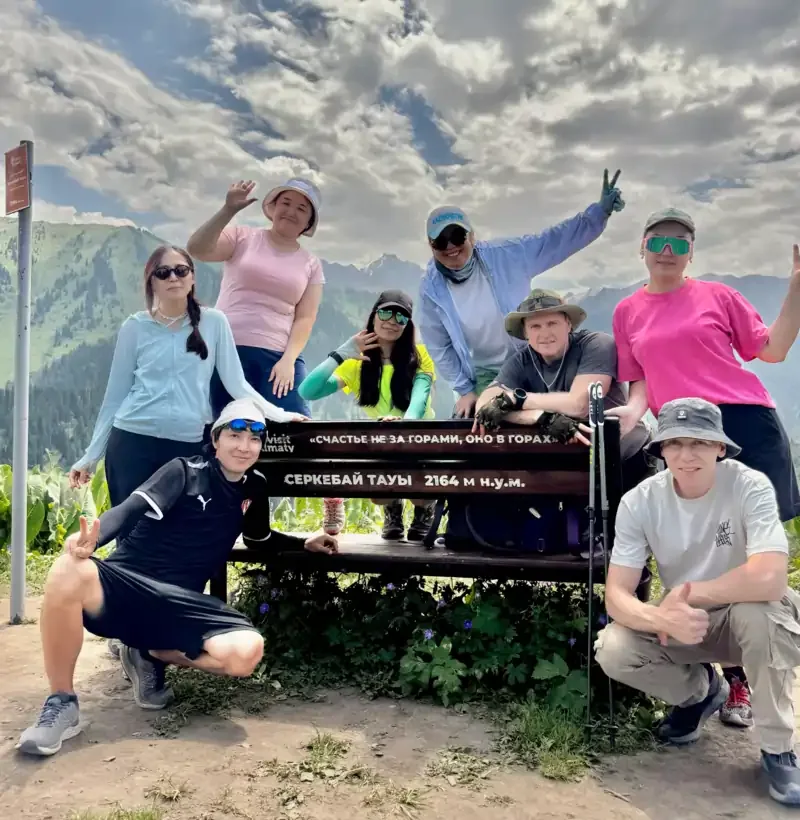
Slonikha viewpoint and Karakungey Mountain, 1,825 mAscent to Serkebay
Follow the ridge from Karakungey to Serkebay. At the highest point of the route, we take our main break, have a snack, and rest before heading back.
Serkebay Mountain, 2,160 mDescent
Descend along a different route, with views of Kimasar Gorge along the way.
Serkebay - Medeu bus stopDescription
The hike to Karakungey and Serkebay is a one-day route in the Almaty mountains near Medeu. The trail follows the watershed ridge between the Malaya Almatinka and Butakovka gorges. Along the way, hikers visit the Slonikha viewpoint, climb Karakungey and continue to the higher Serkebay Mountain.
The main feature of the route is its open panoramic views. From the ridge, hikers can see Almaty, the Medeu complex and dam, the cable car, Kimasar Gorge and the peaks of the Trans-Ili Alatau. Much of the trail follows an open ridge, so the views are not limited to the final destination.
Key details for Route 167
Area: Almaty mountains, Medeu area
Starting point: lower station of the Medeu - Shymbulak cable car
Key landmarks: Slonikha, Karakungey and Serkebay
Elevation of Karakungey: 1,825 m
Elevation of Serkebay: 2,160 m
Total distance: approximately 12 km
Elevation gain: approximately 600-650 m
Duration: 4-6 hours, including stops
Route type: return to the starting point
Difficulty: moderate
Trail surface: dirt paths, forest sections and an open mountain ridge
The actual distance may vary slightly depending on the selected ascent and descent.
Where are Karakungey and Serkebay?
The Karakungey ridge is located near Medeu and separates the Malaya Almatinka and Butakovka valleys. Its position offers an unusual perspective on some of Almaty’s best-known mountain locations.
Karakungey sits approximately 1,825 metres above sea level. It is the first main summit on the route. Although considerably lower than Serkebay, its open position provides clear views of the city, Medeu and the surrounding gorges.
Serkebay Mountain lies farther along the ridge. Its elevation is approximately 2,160 metres. It is the highest point of the hike and the main destination of the full route.
Starting the route near Medeu
The hike begins at the bus stop near the lower station of the Medeu - Shymbulak cable car. The starting elevation is approximately 1,580-1,600 metres above sea level.
The first sections follow roads and trails near Medeu. The route then gradually moves onto the slope and begins to gain elevation. Along the way, hikers pass through forest sections, open clearings and old garden areas.
Tourist signs are installed at the main junctions. The condition of the signs and individual trail sections may change.
Slonikha viewpoint
The first notable point on the hike is the Slonikha viewpoint. It is located on the Karakungey ridge and serves as a convenient place for a short break.
The viewpoint overlooks Medeu, Maloye Almatinskoye Gorge, the city and the opposite mountain slopes. It is a good place to stop, photograph the panorama and assess the next section of the route.
Slonikha can also be a separate destination for a shorter walk. On the full route, it is an intermediate point before Karakungey and Serkebay.
Ascent to Karakungey
After Slonikha, the route continues along the ridge towards Karakungey Mountain. The summit sits at an elevation of approximately 1,825 metres.
The ascent is not technically difficult, but some sections have a noticeable incline. Much of the ridge is exposed to the sun and wind. It can feel hot in warm weather, while wind can make the temperature feel lower during colder conditions.
From Karakungey, hikers can see the Malaya Almatinka valley, Medeu, the urban area of Almaty and Butakovka Gorge. To the south, there is a panorama of the higher peaks of the Trans-Ili Alatau.
After a stop at Karakungey, the route continues towards Serkebay.
From Karakungey to Serkebay
The section between Karakungey and Serkebay follows the ridge, with alternating short ascents and descents. The trail is mostly unpaved and easy to follow in dry weather.
The elevation gradually increases along the way. The city falls behind, and the surrounding landscape becomes more mountainous. The Medeu area and Maloye Almatinskoye Gorge are visible on one side of the ridge, with Butakovka and Kimasar on the other.
After rain, the ground on the ridge may become slippery. Take particular care on steep descents, grassy slopes and shaded forest sections.
Serkebay Mountain
Serkebay is the highest point of the route. The mountain sits approximately 2,160 metres above sea level.
The summit offers panoramic views of Medeu, the surrounding mountain ridges, Kimasar Gorge and Almaty. The open terrain provides a wider view than the lower points of the route.
Serkebay is the recommended location for the main rest stop. Choose a safe place away from the edge of the slope and the main trail. After the break, the group returns to the lower cable car station.
Distance to Serkebay via Karakungey
The full route from the lower cable car station near Medeu through Slonikha, Karakungey and Serkebay, returning to the starting point, is approximately 12 km.
Key figures:
Starting elevation: approximately 1,580-1,600 m
Karakungey: 1,825 m
Serkebay: 2,160 m
Highest point: 2,160 m
Total elevation gain: approximately 600-650 m
Round-trip distance: approximately 12 km
Duration: 4-6 hours
The completion time depends on the group’s pace, the length of rest stops, the weather and trail conditions.
What you will see during the hike
The route includes several points of interest:
Slonikha viewpoint;
Karakungey Mountain;
Serkebay summit;
Medeu complex and dam;
lower cable car station;
Maloye Almatinskoye Gorge;
Butakovka Gorge;
Kimasar Gorge;
panoramic views of Almaty;
peaks of the Trans-Ili Alatau.
Most of the views open directly from the ridge. This makes the route interesting not only for its final destination but also for the walk between the summits.
Hike difficulty
This is a moderately difficult route. In dry conditions, the main trail does not involve rock climbing or technically difficult obstacles, but hikers need a reasonable level of physical fitness.
The main physical demands are:
a distance of approximately 12 km;
up to 650 m of elevation gain;
several hours of walking over uneven terrain;
open sections exposed to the sun;
unpaved ascents and descents.
The route is suitable for active beginners who can walk on a mountain trail for several hours. For a first hike, choose dry weather and go with someone familiar with the area.
Best time to hike
The route can be completed in different seasons, but conditions change significantly throughout the year.
In spring, the open sunny slopes help the ridge clear of snow quickly. However, mud and ice may remain in the forest and shaded areas.
In summer, the route is easy to follow, but there is little shade on the exposed ridge. Start the hike in the morning and carry enough water.
In autumn, the ridge is usually cooler and visibility may be better. Unpaved descents become slippery after rain.
In winter, warm clothing and footwear with good traction are required. Check the snow depth, wind and trail conditions before setting out.
What to bring
Recommended equipment includes:
hiking shoes or boots with non-slip soles;
weather-appropriate clothing;
a warm layer and windproof jacket;
a raincoat;
a hat;
enough water;
snacks or a packed lunch;
trekking poles;
sun protection;
a personal first-aid kit;
a fully charged phone;
a power bank.
The open ridge offers little protection from the sun and wind. Mountain weather may change quickly even when the forecast is clear.
Safety on the route
Despite its proximity to the city, the hike takes place in mountain terrain. Check the weather forecast and trail conditions before setting out.
Key recommendations:
Start the route in the morning.
Do not go onto the ridge during a thunderstorm or strong winds.
Keep away from the edges of slopes.
Take care on wet and shaded sections.
Do not follow poorly marked side trails.
Monitor the time and the group’s pace.
Take all rubbish with you.
If the weather worsens, it is safer to turn back at Karakungey or Slonikha instead of continuing to Serkebay.
Frequently asked questions
How far is Serkebay from the cable car via Karakungey?
The full route, including the return to the lower cable car station, is approximately 12 km.
What is the elevation of Karakungey?
Karakungey Mountain sits approximately 1,825 metres above sea level.
What is the elevation of Serkebay?
Serkebay Mountain sits at an elevation of approximately 2,160 metres. It is the highest point of the route.
Where does the hike start?
The route begins at the bus stop near the lower station of the Medeu - Shymbulak cable car.
How long does the hike take?
The average duration is 4-6 hours, including rest breaks and stops at the viewpoints.
What is along the route?
The route first passes the Slonikha viewpoint, then crosses Karakungey and continues to Serkebay Mountain.
Is the route suitable for beginners?
It can be suitable for beginners with reasonable physical fitness in dry weather. Hikers should consider the 12 km distance and approximately 600-650 m of elevation gain.
Summary
The hike to Karakungey and Serkebay is suitable for those who want to see panoramic views of Medeu and the Almaty mountains without travelling far from the city. The route starts near the lower cable car station, passes the Slonikha viewpoint and Karakungey, then climbs to Serkebay.
The total distance is approximately 12 km, including the return to the starting point. Karakungey sits at 1,825 metres, while Serkebay reaches 2,160 metres. Allow 4-6 hours depending on the weather and the group’s pace.
В городе было очень жарко, но в горах совсем другое дело. Отличный маршрут совсем недалеко от Медео. Шикарно провели день. Отличная организация. Только положительные впечатления.
Дмитрий


